Файл:Eurozone.svg
Перейти к навигации
Перейти к поиску


Размер этого PNG-превью для исходного SVG-файла: 450 × 456 пкс. Другие разрешения: 237 × 240 пкс | 474 × 480 пкс | 592 × 600 пкс | 758 × 768 пкс | 1011 × 1024 пкс.
Исходный файл (SVG-файл, номинально 450 × 456 пкс, размер файла: 417 Кб)
Краткое описание
| Описание |
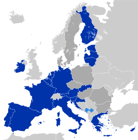
Deutsch: Eurozone
Staaten, die den Euro de jure angenommen haben Staaten und Gebiete, die den Euro de facto angenommen haben EU-Mitglieder außerhalb der Eurozone English: Eurozone
Countries using the Euro de jure Countries and territories using the Euro de facto EU member states that are outside the Eurozone Français : Zone euro
Pays ayant adopté l'euro de jure Pays et territoires utilisant l'euro de facto États membres de l'Union européenne n'ayant pas adopté l'euro Hrvatski: Eurozona
Članice Eurozone Države koje koriste Euro kao sredstvo plaćanja, ali su izvan Eurozone i Europske unije (Kosovo i Crna Gora) Članice Europske unije koje su izvan Eurozone Latviešu: Eirozona
Valstis, kuras izmanto eiro de jure Valstis un teritorijas, kuras izmanto eiro de facto Eiropas savienības dalībvalstis ārpus eirozonas Polski: Strefa Euro
Kraje używające Euro de jure Kraje i terytoria używające Euro de facto Członkowie Unii Europejskiej będący poza strefą Euro Português: Zona Euro
Países que adotaram de jure o euro Países e territórios que utilizam de facto o euro Estados-membros da União Europeia que não adotaram o euro Српски / srpski: Еврозона
Чланице еврозоне Државе и области, које користе Евро као средство плаћања, али су ван Еврозоне и Европске уније (Црна Гора и Косово) Чланице Европске уније, које су ван Еврозоне Українська: Єврозона
Країни, що використовують Євро де-юре Країни та території, що використовують Євро де-факто Країни-члени ЄС за межами єврозони فارسی: منطقه یورو
کشورهایی که یورو را به طور رسمی پذیرفتهاند کشورها و مناطقی که از یورو به عنوان وسیله پرداخت استفاده می کنند اما عضو منطقه یورو نیستند کشورهای عضو اتحادیه اروپا که خارج از منطقه یورو هستند |
| Дата | |
| Источник | Europe countries.svg |
| Автор | Glentamara |
| SVG‑разработка |
Лицензирование
| Я, владелец авторских прав на это произведение, передаю его в общественное достояние. Это разрешение действует по всему миру. В некоторых странах это не может быть возможно юридически, в таком случае: Я даю право кому угодно использовать данное произведение в любых целях без каких-либо условий, за исключением таких условий, которые требуются по закону. |
История файла
Нажмите на дату/время, чтобы увидеть версию файла от того времени.
| Дата/время | Миниатюра | Размеры | Участник | Примечание | |
|---|---|---|---|---|---|
| текущий | 08:47, 2 марта 2023 | | 450 × 456 (417 Кб) | Discombobulates | Unify Cyrpus, recognised by the EU as one state |
Использование файла
Следующие 2 страницы используют этот файл: